
Online Manual
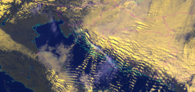
In the wind section of the satellite manual SatManu, there is a new conceptual model on Bora. Bora, or bura, is a gusty, northeasterly, downslope wind that often occurs along the eastern Adriatic coast, at the leeward side of the Dinaric Alps.
Bora blows from the north east quadrant over the coastal mountains, which are approximately 1000 m high, usually bringing colder and relatively drier air to the Adriatic. In strong Bora episodes hourly mean wind speeds often surpass 20 m/s, with gusts reaching up to 50, or even 65 m/s. Severe Bora with maximum gusts exceeding 40 m/s may appear along the entire Adriatic coast, but its duration and frequency generally decrease from north to south.
Bora significantly affects the dynamics of currents in the Adriatic Sea. It causes difficulties with aviation as well as land and marine traffic: in most cases it has an unfavourable impact on agriculture.
To get more information and an in depth view of Bora, please visit EUMeTrain’s SatManu page.